

A couple of days ago we had the pleasure to meet Guido Parissenti, founder and CEO of Apogeo Space, a novel company building the first Italian satellite constellation for IoT. In the interview, we discussed about the development of nanosatellites and picosatellites, the use of automotive-grade components in satellite construction, the impact of geopolitical scenarios on satellite operations and much more. In the following lines, the full interview.
Good morning, Guido. Tell us about yourself and the company. How did Apogeo Space come about?
The company was co-founded by myself and Primo Attinà. We met at Thales Alenia Space in Turin, a company specialised in large scientific satellites like GOCE, Plato, and Beppo-SAX, contributing to half of the Western International Space Station’s volume. Inspired by our desire to experience the full lifecycle of space projects, we left to establish what would later become Apogeo Space, which was later bolstered by the support of Primo Space Fund in 2022 [which invested €5 million in our venture], which prompted our rebranding while preserving our existing expertise and corporate structure.
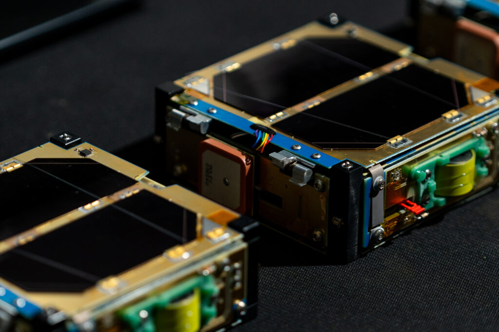
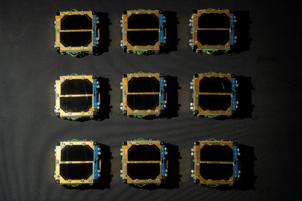
Anticipating the importance of miniaturisation in the New Space market, we focused on microsatellites—specifically nanosatellites. We launched our first demonstrators in 2021 and 2022, featuring very small platforms one-third the size of CubeSat units, formally known as picosatellites weighing less than a kilogram, while adhering to CubeSat standard dimensions. This approach maximises launch opportunities compared to smaller satellites like PocketCubes, achieving efficiency through miniaturisation to condense the capabilities of larger satellites into smaller ones.
Choosing telecommunications over imaging due to the challenges of integrating high-resolution cameras into small satellites, our emphasis on connectivity uptime became paramount. Upon operational readiness, our company will provide satellite telecommunications solutions for IoT using a constellation of low-orbit satellites. Despite the low latency of these satellites, which are non-geostationary by definition, ensuring continuous data transmission necessitates a network of multiple satellites.
Our strategy centres on miniaturisation to rapidly deploy numerous satellites, offering an economically viable path to deliver continuous telecommunication services with frequent contact opportunities throughout the day. By 2027, our roadmap aims to establish a constellation of a hundred satellites to achieve seamless coverage.

You mentioned OneWeb and Starlink earlier, and as you said, the investment difference is huge. What is different in the service you offer, and why do you consider yourselves competitive?
We specialise in IoT telecommunications, contrasting with broadband providers like Starlink. Our focus is enabling the monitoring of small, remote objects powered by batteries or solar panels—whether in deserts, glaciers, or ships in the Pacific—with minimal data requirements such as temperature, humidity, and GPS locations. While broadband services like Starlink cater to high-bandwidth needs like internet access, our service supports applications where transmitting small data packets economically is crucial.
The global IoT market is poised for exponential growth, projected to encompass 50 billion devices by 2030. Many of these devices will operate in remote environments, away from traditional Wi-Fi coverage, driven by environmental monitoring needs exacerbated by climate change. This necessitates innovative solutions like ours to transmit vital data from inaccessible locations efficiently.
Moreover, satellite communications offer significant advantages over terrestrial alternatives. For instance, in regions like East Asia, where differing regulations necessitate changing SIM cards across borders, our satellite-based solutions simplify operations and reduce logistical complexities. Similarly, in smart cities and infrastructure monitoring, satellites streamline processes by avoiding the need for frequent SIM card replacements during infrastructure changes or competitive bidding cycles.
At heart, our approach leverages satellite technology to address critical IoT needs efficiently and economically across diverse global applications.
Let’s stick to possible applications. We have recently seen during the Space Meetings Veneto that today satellite applications often go hand in hand with the use of drones, for example, in smart agriculture. Can you give us your opinion on this? Do you see drones as an alternative or complementary tool to satellites?
Absolutely, they complement each other. In my past work with drones, satellites were always seen as competitors. The crucial difference lies in resolution: Sentinels offer about 11 meters per pixel, while modern high-resolution satellites reach 30 centimetres per pixel. Drones achieve 1 or 2 centimetres per pixel.
In the United States, where wheat fields span hundreds of square kilometres, satellite resolution suffices due to the scale, making drone monitoring impractical. Conversely, drones offer a clear advantage in Italy, where agricultural plots average 3 hectares and often include high-value crops like horticulture and fruits. The advantage resulting from both satellite and drone prescription mapping is maximised when integrated with existing precision agriculture technologies such as automated tractors and spreaders, which previously relied on agronomists manually sampling fields to create prescription maps.
Moving to IoT applications, both satellite and drone imaging play essential roles but aren’t sufficient alone. While satellites provide an overview, ground-level parameters require absolute measurements. Take soil moisture, for example, where thermal imaging can gauge relative humidity across a field. However, precise data from ground sensors are essential to accurately manage irrigation or other interventions and to convert relative readings into absolute values for effective decision-making. IoT can effectively achieve this.
Let’s talk more about your satellite specifically. You rightly explained why you tried to keep the CubeSat as a reference standard. Does this also help in choosing the components? I also ask you how much of the satellite you develop directly.
We use automotive-grade components, it’s no secret, but more than the size of the satellite, what guides the choice of components is the expected lifespan of the satellite. This means you can make a big satellite, but if you know it must stay in orbit for six months because it does a test in VLEO [very-low Earth Orbit ed.], you can afford to use components with lower radiation survival because they cover the operational life anyway. We use automotive components that start well because automotive has very high standards anyway. And then we protect them; clearly, they are not born rad-hard because they are not designed for space, but they have good radiation tolerance. We also help them, in some cases by shielding them, in others by introducing electronic or software solutions to prevent or counteract non-destructive effects due to radiation. Having said that, our satellites usually have a lifespan of 2-3 years. Either because that specific launch puts them in an orbit where they naturally decay in that duration or because we will also implement a deorbiting device that will allow us to clear the orbit after that time. Why 2-3 years? Because we plan to keep this constellation always updated.
So, you do already have a plan to replace the satellites gradually.
Yes, once we reach 100 satellites, we won’t stop launching them to keep the constellation up to date. This means that every 2-3 years, we will decommission the satellites that are up there. However, we can’t leave them in orbit for years because of the debris problem, so we have a passive device—a sail that deploys and significantly reduces the object’s time in orbit. The aerodynamic drag causes them to decay much more quickly.
Could you elaborate on this? It’s clear that deorbiting and debris mitigation are very hot topics today. From your perspective, how is this issue evolving, and what is the role of private entities and institutions?
This fits into the broader topic of various space laws that are about to be approved in Europe and Italy, which, besides issues of operator responsibility, also impose themes of orbital sustainability, let’s call it. It’s a topic that institutions addressed when they realised that they were no longer the only ones managing space, and they rushed to catch up. But yes, they are moving, even if it’s a bit scattered, and the timelines are quite long. I started hearing about satellites capturing other satellites to reduce the risk of Kessler Syndrome back in 2012-2013, almost ten years ago. Now, there are 6,000 more satellites, and we are still at the stage of initial in-orbit demonstrations.
Clearly, space has its own timescales, and now there are truly the foundations for a space economy based also on in-orbit servicing, such as refuelling and recapturing larger satellites for deorbiting to avoid issues. There are increasingly more services that allow you to calculate possible collisions and adjust and optimise your manoeuvres to avoid them. In my opinion, everyone is moving—both the industry, for economic and institutional reasons, and regulatory policy to create legislation. It will likely all come together around the same time with the publication of space laws. Also, space laws provide a kind of legal certainty that allows you to make investments more confidently. Some may be hesitant because, although there are no rules now, they might be tempted to wait a moment before investing significant sums until they understand what the law will say, as this could affect their business plan, or they might feel more reassured because it protects them as investors, knowing that things won’t change afterwards.
In this landscape, how are you moving? Especially regarding satellite technology, are you evolving it? You’re clearly in the constellation launch phase, so many efforts must be on production. Are you still evolving the technology? Do you have future plans?
Yes, we never stop refining the design and implementing new functions. Of course, the design timelines have to align with those of production; you always have to find a compromise between what you want to do and the time available. Our great advantage is that, given the reduced cost, we can afford to replace our assets frequently. So we move forward. For example, the Deorbiting Device is not yet implemented, but we plan to start it next year. In such a miniaturised satellite, changing one part affects the design of everything else, from electronics to mechanics. Updates must consider what we have done so far. Thus, we change plans to replace certain technologies, such as the communication link with the ground station. At the moment, it has a certain capacity, and we plan to change the technology to increase the data exchange capacity between the new satellites, enabling them to download more IoT data with each pass.
Is the ground station in Italy?
The ground station is in Italy. We will also have others abroad to have more contact opportunities for downloading this data. But yes, the primary one is here.
These last topics, especially the development of space laws and the strategic positioning of ground stations, open up another interesting issue, which is geopolitics. There’s a lot of activity now, and geopolitical scenarios also influence a company’s development possibilities. As you mentioned earlier, LEO satellite applications are often global, so I imagine the clientele you are targeting is global as well, and the business can be influenced by geopolitical relations. Can you comment on this?
It’s well known the geopolitical use that the Starlink constellation has from this point of view. Never mind the fact that they turn on and off whenever they want. The Starlink constellation is an asset, an infrastructure inherently resilient to external attacks as even if you shoot down a satellite with a missile, there are still 5-6 thousand others available, and they are now equipping to avoid jamming, making it an infrastructure resilient to turbulences. In our small way, we are creating a satellite infrastructure composed of a large number of satellites that are completely under Italian control. While our uses are civilian, this is still an asset.
That said, I can communicate at any point on the globe while staying in Italy. After Covid and the outbreak of the conflict in Ukraine, such a characteristic is becoming an added value or at least a point of interest. The geopolitical situation means that all these projects are gaining more value from the perspective of the nation that holds them. This is also true in the private sector; there are large companies or institutions that decide to equip themselves with custom constellations because, nowadays, launching a few satellites into orbit is no longer an investment that only NASA or Boeing can afford. So, this is also a mode of operation being considered now, which was previously unthinkable.
And this also applies to Apogeo Space. Could you provide a final comment on the company’s future prospects, including the human resources aspect, not just technology? I didn’t ask before about the company size; how many employees do you have?
We currently have 22 employees and also collaborate with external partners. We are very happy because we managed to close the loop regarding in-house expertise for satellite development. We have teams in mechanics, electronics, firmware, etc., which allows us to be independent from external consultants or other companies for designing our satellites. Of course, we plan to grow further, especially reinforcing the commercialisation aspect, because now, with the satellites ready, it’s time to start the business and begin working with clients. However, we also plan to increase in number to take advantage of opportunities we previously had to pass on because we were focused on our roadmap. Now that we have acquired design expertise, we can design our satellites from scratch and also design satellites for others. So, we can also undertake larger projects depending on the client’s interest in our capabilities.
So, as you say, the constellation is in an advanced stage, but the acquired know-how also makes you look to the future.
Of course, we have people who know how to build satellites. If we just kept them assembling screws, we might be misusing their time and capabilities.


About Guido Parissenti:
Guido Parissenti, born in 1983, is the CEO and co-founder of Apogeo Space. He brings over 15 years of experience in the space industry, holding a space engineering degree from the Polytechnic of Milan (with a thesis conducted at Princeton University) as part of the Alta Scuola Politecnica’s dual degree program. He later earned a PhD in Energy Engineering from the same institution.
Prior to founding Apogeo Space (originally GP Advanced Projects) alongside Primo Attinà in 2015, Guido spent 6 years at Thales Alenia Space in Turin, where he served as a propulsion specialist and program manager. Their vision at Apogeo Space is to establish Italy’s first private satellite constellation, aimed at providing global telecommunications services for the Internet of Things (IoT).
Throughout his career, Guido has significantly contributed to projects at prestigious institutions including ESA (European Space Agency), ASI (Italian Space Agency), and NASA. His collaborations extend to renowned research institutes such as INAF (National Institute of Astrophysics), INFN (National Institute of Nuclear Physics), Brera Astronomical Observatory, Bologna Astronomical Observatory, and Milan Polytechnic.
